We left the friendly
confines of Yukon under a High risk. This category is reserved only for days
with the highest potential for large, long-track tornadoes. The SPC had also
include a 45% chance of tornadoes, some of which were forecast to be violent
(EF2+). Indeed, some of the language being used by the SPC in their discussions
had been used on days Like April 27, 2011 when many lost their lives in a
series of tornadoes which ravaged the state of Alabama.
 |
| A rare sight |
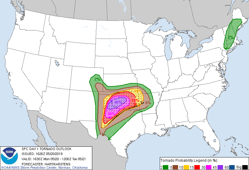 |
| Tornado probability. Not what you like to see. |
The morning soundings
confirmed our concerns. Nothing was missing from the atmosphere. It was only a
matter of time.
We left for Altus, OK
at 10AM. Everyone was anxious. The clouds were very close to the surface,
indicating the very high dew points. The sun was hidden behind a veil of clouds.
Upon reaching Altus
we took some time to fuel the van and eat a quick lunch (at Braum's; as much as we ate at Braum's on this trip we should see if they will sponsor us in the future). We went to a nearby park and
met up with some friends and colleagues from Mississippi State.
Together, we watched storms fire along the dry line near Lubbock. It did not take long for the storms to become severe and start generating tornado warnings.
 |
| Kicking it at the park in Altus. It's behind the Hobby Lobby. Photo: Hunter Reeves. |
Together, we watched storms fire along the dry line near Lubbock. It did not take long for the storms to become severe and start generating tornado warnings.
 |
| Initial storms. Blue circle is our position. |
We moved west towards
Gould to intercept these storms. We would have moved into Texas except we had
received word of lane closures and traffic backed up for miles on the highway
we would have used. We were forced to play the waiting game.
Eventually the storms
arrived. And so did the chasers. It started off with a few cars near Gould, but rapidly grew into a convoy as we backtracked towards Mangum. There must
have been close to 100 cars on the roads at this time.
We saw a few base
lowerings/wall clouds but no tornadoes. Unfortunately, we became trapped in the
middle of the pack of chasers and missed out on a tornado just north of Mangum.
We stayed in pursuit of the storm before it merged with other storms. We moved
northeast towards Granite and Sentinel, getting caught in a torrential downpour
before we could see anything.
We kept watching the
radar and trying to position ourselves favorably, but it became apparent that
the system was transitioning into a heavy rain producer. It would be worth
researching why the tornado count was so low on this day, given the high
potential. We speculated about the capping inversion being too weak, or too
much moisture being present, but could come to no conclusions.
When it became
apparent that the situation was unchaseable, we turned east and headed for
home. Along the way we went through several more bands of heavy rain before breaking into the clear near Shawnee, OK.
Greg and I took shifts
behind the wheel for the 9-hour drive home. We were all ready to be out of the
van by the time we rolled into Martin at 730 AM on Tuesday.
We bid farewell to
the great group of students and returned the van.
And, just like that, we were done with chasing. Over 4000 miles of driving, 6 different states, 2 awesome steaks, 1 traffic jam, and a young man with a basketball and a dream. It was a great experience and I believe we all learned something valuable. I can't wait to go again
And, just like that, we were done with chasing. Over 4000 miles of driving, 6 different states, 2 awesome steaks, 1 traffic jam, and a young man with a basketball and a dream. It was a great experience and I believe we all learned something valuable. I can't wait to go again
Thanks for reading!


No comments:
Post a Comment