Thursday dawned and
it was time to (reluctantly) bid farewell to Canyon. At least for today; there
was a chance we would be back on Friday (or even the following Monday)
depending on where the storms formed. But for today we were headed back to New
Mexico to check out the Capulin (Cah-poo-leen) volcano.
 |
| Capulin |
Capulin, which means
“choke cherry” in Spanish, is part of a field of dormant volcanoes in the far NE
corner of the state. As we drove, we saw a few of the other volcanoes. They
stood in stark contrast to the otherwise flat land. In all my travels across
the heart of the country, I had yet to visit Capulin. Seeing all those other
cinder cones had me pretty excited.
We stopped at the
visitors center to pay the entry fee. Then it was up a narrow, winding road to
the edge of the caldera. We were nearly 9000 feet above sea-level when we
arrived at the top. I could definitely feel the reduced oxygen content.
The views of the
volcano and the surrounding flat plains were amazing. It made me wonder
what it would be like to observe storms from there. Honestly, probably not the
best idea because of lightning. We were at a high enough elevation to see the
snow-covered slopes of Taos, NM in the distance.
 |
| Real and spectacular |
 |
| View from Capulin. Photo: Hunter Reeves |
 |
| In the Capulin caldera |
There were two trails
you could walk while at the top. One went around the rim of the caldera while
another went down into the caldera itself. I guess I was the only one who did
not complete the caldera trail; it was quite steep and I tired quickly after a
short ascent. I returned to the parking lot and walked down into the caldera.
It was a fascinating experience despite the physical toll.
Take the Capulin tour with Shaley Dawson:
Take the Capulin tour with Shaley Dawson:
Our adventure
complete, we headed for Dumas, TX to spend the night. Dumas was a location
which offered many possibilities. It was ideally located for any storms that
developed in the Panhandle region. And if for some reason that possibility
evaporated, we could still get up early the next morning and make our way
either north (Nebraska) or further south (Ft. Stockton).
 |
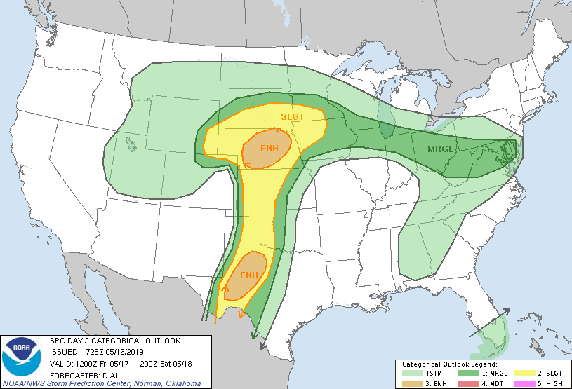
| Outlook for Friday. Decisions, decisions |
 |
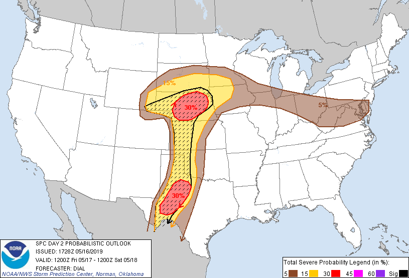
| Probabilities of severe weather. The black hatching indicates the probability of significant severe weather (Hail > 2", EF2+ tornadoes, a/or Wind gusts of 65+ kts) |
After dinner, Greg
and I met to discuss look over the data and discuss the possibilities. It was
clear to us that we had three possible options:
1) Get up and go
north to the Nebraska Panhandle, where the capping inversion would weaken and
tornadic storms would develop.
2) Get up and head
south towards Ft. Stockton where the atmospheric dynamics weren’t quite as
impressive, but there was a lot of instability.
3) Wait in the
Panhandle. There would be plenty of wind shear and instability, enough to rival or surpass the other two, but a strong cap would be in place most of the day. The key would be the dry line and any uplift it could provide.
Of the three, option one had the least
risk. We felt strongly that there would be tornadoes in Nebraska. But that
would take us out of position for chasing on Saturday. We thought there was a
decent risk for storms in eastern Texas in the late afternoon on Saturday. Chasing in Nebraska would leave us out of range for Saturday.
The same could be said for option two (Ft.
Stockton). Tornadoes might be a little less likely there because of the weaker
dynamics. But the weather models were showing only a storm or two developing; less competition meant easier access to a greater amount of instability. But,
again, chasing there would put us out of position for Saturday.
Option three was the riskiest as there
was no guarantee that the cap would break. It was entirely possible that we
could sit there all day with nothing to show for it. But, if it did we would
have three more shots at chasing, including Monday which was shaping up to be a
full-fledged tornado outbreak.
Rather than make the call ourselves, we
contacted the students and asked for their input. After presenting all of the choices, they elected to stay in the
Panhandle in order to maximize our chasing opportunities. With that decided, we all
went to bed to see what Friday would bring.


No comments:
Post a Comment