Welcome one and all to the blogosphere home for the University of Tennessee at Martin Meteorology program.
Be sure to check back often for updates.
Wednesday, June 5, 2019
2019: A Chase Odyssey
The following posts detail the Great Plains Travel Study for 2019.
Before you start reading, know that this is a work in progress. As more images come in from the students, I will be updating the blog. I appreciate the contributions of the students.
On behalf of the group, I would like to thank:
The College of Agriculture and Applied Science. Particularly Dr. Todd Winters and Debbie Hunter for helping us to secure funds for the students.
Mrs. Evelyn Blythe, for providing those funds.
The Department of Agriculture, Geosciences, and Natural Resources, (Dr. Wes Totten, Mrs. Carrie Arant) for their assistance, both monetary and administrative, with the trip.
The folks in the Travel Study office (Lorrie Jackson, Jewel Franklin, Mike Sudzum) for their assistance and support.
Dr. Malcolm Koch and Dr. Joey Mehlhorn for giving us the green light for the trip.
Enjoy the read! Contact me if you have any questions.
Day 1 - Yukon Ho! - May 10, 2019
On a brisk Friday morning, seven students
and two instructors set out from Martin on the first Great Plains Travel Study
offered by the University. Despite the cold weather, all were excited to get on
the road for this ten-day adventure across the flatter parts of our great
nation. Our initial destination was Yukon, OK.
The goal of the trip was to forecast for,
pursue, and observe severe thunderstorms. We were in search of all the hazards
associated with such storms: large hail, damaging winds, and tornadoes. We were
not going out there for thrills alone; this would be a unique opportunity to
experience the things described in the textbooks. After all, it's one thing to read about inflow into a severe storm, quite another thing to feel the wind at your back.
On days where there were no storms to
observe, we would look for cultural and natural landmarks to explore. Given the
overall weather pattern, we would get to see more than our fair share of such
for most of the time. A large upper-level trough covered the country east of
the Rockies. That explained the colder than normal weather which, in turn,
would inhibit the development of severe weather for much of the next 7 days.
After that, the models were hinting at a pattern change.
We left Martin equipped with internet
access, two iPads, and a SiriusXM radio. Internet access is critical for storm
chasing; it provides the data necessary to find the storms and stay ahead of
them. We would use the iPads to both display radar data and navigate the road network. The
radio would help to pass the time; you see, just to get onto the cusp of the
Plains, we were looking at a 10-hour trip. The Great Plains are too far away from Martin.
While the overall pattern was quiet, that
doesn’t mean the sky was empty of wonders. We saw several interesting clouds
along the way. We saw asperatus clouds; these are gray, wavy clouds which
indicate the presence of turbulence. This is one of the newest clouds officially
designated by the World Meteorological Organization.
Next up was mammatus. These pouch-like clouds typically develop in the vicinity of severe thunderstorms, but they can also form in other, less turbulent conditions (like today).
Next up was mammatus. These pouch-like clouds typically develop in the vicinity of severe thunderstorms, but they can also form in other, less turbulent conditions (like today).
We also saw some cumulus forming from the
emissions of nuclear reactors in Arkansas.
At long last we reached the Holiday Inn
Express in Yukon. This chain is a favorite with chasers as the hotels are
clean, comfortable, offer free wi-fi and a hot breakfast each morning. This
particular hotel was undergoing renovation while we were there, but it did not
impede us in any way.
Most of went to Rib Crib for dinner. As the
name suggests, ribs are their specialty. And they did not disappoint.
Day 2 - The Scenic Route to Lubbock - May 11, 2019
Saturday dawned much as the Friday did;
cloudy, cold, and moist. These are the antithesis of severe weather conditions.
I am sure the fine people of Yukon were fine with this; Oklahoma gets more
than its fair share of severe weather this time of year.
One thing to clarify: we don’t come out
here hoping, or cheering, for severe weather to occur. We are not bloodthirsty
maniacs, after all. However, it tends to happen out here regardless of what anyone
does. Since that is the case, we came here to see it and, more importantly, learn from it. It is my fervent hope
that the things the students witness will make them better meteorologists,
determined to provide ample warning to the public.
Our ultimate destination for this day was the town
of Wolfforth, TX; a suburb of Lubbock. The Storm Prediction Center (SPC), and
the weather models, were hinting at the possibility of some marginally severe
thunderstorms in SW Texas, from Lubbock towards the Trans Pecos region (see
map). We felt that the Lubbock area was a good staging area. We could either
chase around there or move quickly to the south should the threat area shift.
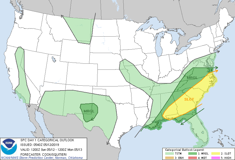 |
| SPC Outlook for Sunday |
But our first stop for the day was the National
Weather Museum and Learning Center in Norman. The museum is a hidden jewel for weather folks, featuring
numerous exhibits which detail the origins and growth of the science of
meteorology. We were escorted about the premises by Mr. Forsyth who worked at
the National Severe Storms Laboratory (NSSL). He was a great guide, providing
insight into many exhibits.
 |
| Mr. Forsyth shows off the computer associated with the first Doppler. |
 |
| How radar data used to look.... |
 |
| Various weather instruments |
 |
| What's left of a car. Always seek sturdy shelter when tornadoes approach |
Mr. Forsyth related a story about the first
attempts to sample the upper levels of the atmosphere. The story was excerpted
from Savannah Tennyson’s chase journal:
“when the first meteorologists were
testing the upper atmosphere and learning about how the atmosphere works they
would fly to about 19,000 feet; however, there is a lack of oxygen that high in
the atmosphere which caused some people to die. To resolve this problem the
pilots would bring their small animals up with them and when they started
getting drowsy they knew the needed to go back towards the ground because they
were in the zone of thin oxygen.”
The Museum also featured a “green screen”,
or chromakey wall, where students could practice reporting the weather as it is
done on television.
 |
| Keith Gregory stretches his TV legs in front of the Green Screen |
 |
| Shannon Sullivan at the Wall. The cape adds an interesting effect. Now you see her... |
 |
| Now you don't. |
We made our way to the library, which
featured one of the largest collections of weather books I have ever seen.
Fortunately, we had time for a few stories.
 |
| Story Time (Photo: Greg Nordstrom) |
Finally, the Museum is in the process of
restoring a plane used for thunderstorm research. Similar to the Hurricane
Hunters, there was once a plane designed to fly through severe thunderstorms..
 |
| Panorama of the museum. Thunderstorm plane on the left. Photo: Savannah Tennyson |
 |
| Savannah at the helm |
We left the Museum and made our way towards
Lawton for lunch. We traveled Interstate 44, which is a toll road through Oklahoma.
For some of our students this was their first experience on a toll road. Other
than the increased speed limits, there isn’t much to recommend it. Though we
did pass the Elmer Graham Turnpike Station. You can learn about this
extraordinary man here:
From Lawton, we worked our way south and
west towards Lubbock. Somewhere along the way, we (okay, I) took a turn towards the
south. We nearly made it to Abilene before realizing the mistake. Our detour
cost us about an hour but it did give us a chance to see more of the
extraordinary landscape of Texas. Basically, aside from a few random buttes and windmills, it’s quite flat and largely unpopulated. That makes it perfect for chasing.
After dinner, we settled in for the night.
Day 3 - Actual Storms - May 12, 2019
The calm start to the chase was about to
end. The SPC had placed an area a few hours to our south in a Marginal risk for
severe weather. Marginal indicates that some of the necessary ingredients for
severe thunderstorms were coming together, but it wasn’t a significant threat.
We interpreted the data to mean there was the potential for a supercell
thunderstorm or two, but it wouldn’t produce much in the way of severe weather
(NWS defines a severe thunderstorm as one that produces hail > 1” in
diameter, wind gusts > 58 mph, a funnel cloud, or a tornado).
In other words, we were prepared to drive
quite a distance for a photogenic storm and maybe some small hail. Such is
chasing; you play the cards you are dealt. And with a pattern expected to
remain calm for the next five days, we threw our chips into the pile and drove
south.
As we drove south we noted some
development. One particular storm started to exhibit severe characteristics on
radar, but it fell apart on its approach to Hobbs, NM. This showed us that the
potential was there but something was missing, possibly the necessary
instability to sustain the storm.
We stopped for lunch in Odessa, TX then
moved south towards Ft. Stockton. Another storm formed to our southwest. This
was enough for the SPC to upgrade a Slight Risk and issue a Severe Thunderstorm Watch for the area.
We moved into
position to intercept the storm. The storm was not severe, but it was
interesting to look at it. We found a place where we could view the bulk of the
storm. It was an opportunity for the students to observe the mechanics of the
storm and the parts which make it up. For example, we saw air rising and
condensing as it moved into the updraft portion of the cloud.
 |
| Storm in the Sierra Madera astrobleme. Low clouds are rising into the main updraft. Photo: Hunter Reeves |
 |
| Closer view of the storm. Lighter colors above the base might (might) have been some small hail. Maybe. Photo: Maddie Bernabei |
 |
| Watching the storm. |
But that was about
it. We did manage to get rained on, which was an achievement in itself. After
a few minutes of heavy rain, and with intensity trending downward on radar, we
left the storm behind. We took a restroom break outside Odessa and made our way
to Midland for dinner. Cracker Barrel was the choice for tonight. They think
highly of their dumplings and will be more than happy to serve them to you in
abundance. They also believe it is a vegetable....
The dumplings would
turn out to be more plentiful than the storms for the next week.
Day 4 - In Search of the Truth - May 13, 2019
After doing some
chasing, we were confronted with several more calm weather days. Well, not
entirely. The day dawned with a Slight risk in far south Texas, closer to the Gulf of Mexico. But our analysis suggested that the threat for this day would be much like the day
before. Further, we thought our resources would be better allocated for later
in the week.
So, what to do? The
answer: tourism. Specifically, a journey into New Mexico with an “otherworldly”
destination. We were on our way to Roswell, NM.
For those who may be
unaware, in July of 1947 an unidentified flying object was spotted in the skies
near Roswell. Later, reports emerged that an actual spacecraft had crashed just
outside the city. Further, alien bodies had been discovered in the wreckage.
But, just as quickly, the military moved in and announced that an experimental
weather balloon was the object and that there were no bodies.
Cries of conspiracy
echoed across the country then and continue to this day.
Unfortunately, not
all trips are smooth and easy. We encountered a long traffic delay west of
Tatum, NM. There were multiple cars involved in the wreck and it took 45
minutes to clear the road. The students got out of their van, stretched
their legs, and got acquainted with fellow travelers in the vehicles nearby. We also
met a nice young man dribbling a basketball along the side of the road.
 |
| On the roadside in New Mexico. For the brand... |
The road cleared and our journey resumed. We marveled at the flat terrain, which was covered in dry grasses and scrub brush. Occasionally, we would see hollows and gullies where the soil and rock strata were more susceptible to erosion. And then Roswell appeared on our horizon.
After a delicious,
and nutritious, lunch at the local Dairy Queen, we went to the International
UFO Museum and Research Center. The museum is intriguing and well organized. It presents the
“incident” and the events surrounding it in great detail. It also describes
other encounters throughout history. It makes a strong case that humanity has
been visited by living beings from other worlds.
 |
| The Truth is Here |
 |
| Everybody remember where we parked.... |
Or, you can view it as a tourist trap built around an easily explained military operation over 70 years ago. Both outcomes are possible.
After acquiring
souvenirs from local merchants, we were back on the road. Along the way to our
ultimate destination, we passed through several small towns in eastern New
Mexico and the Texas Panhandle. Many of these towns, including Hereford, TX,
were home to massive feedlots filled with cattle as far as the eye could see.
Even if we had been able to bypass the towns, we would not have escaped the
signature smell of manure. Local folk refer to the scent as the “smell of
money”.
We checked in to the
Holiday Inn Express in Canyon for the first of three nights. We wanted to stay in this area ahead of a growing risk for Friday.We went into town
for dinner and then called it a night.
Day 5 - Canyon Shenanigans and the Big Texan - May 14, 2019
Another day without
storms to chase. That meant more tourist activities, but this time with a more
geosciencey twist (I think I just created a word).
We left the hotel and
drove down the road to Palo Duro Canyon State Park. Palo Duro is the second
largest canyon in the United States and is a fantastic treat for Texas
Panhandle enthusiasts like me. It has stunning views and scenery which rival any other geologic feature on the Plains.
After receiving free
admission to the park because of our education affiliation, we drove to the
overlook and surveyed the landscape. You could very easily see the effect of
erosion on the landscape. Several different layers of sediment were on display
beneath the water-resistant caprock. The vegetation was remarkably vibrant as
well, thanks to a rainy Spring.
 |
| Palo Duro. I never tire of this view. |
 |
| Skyhawks at Palo Duro |
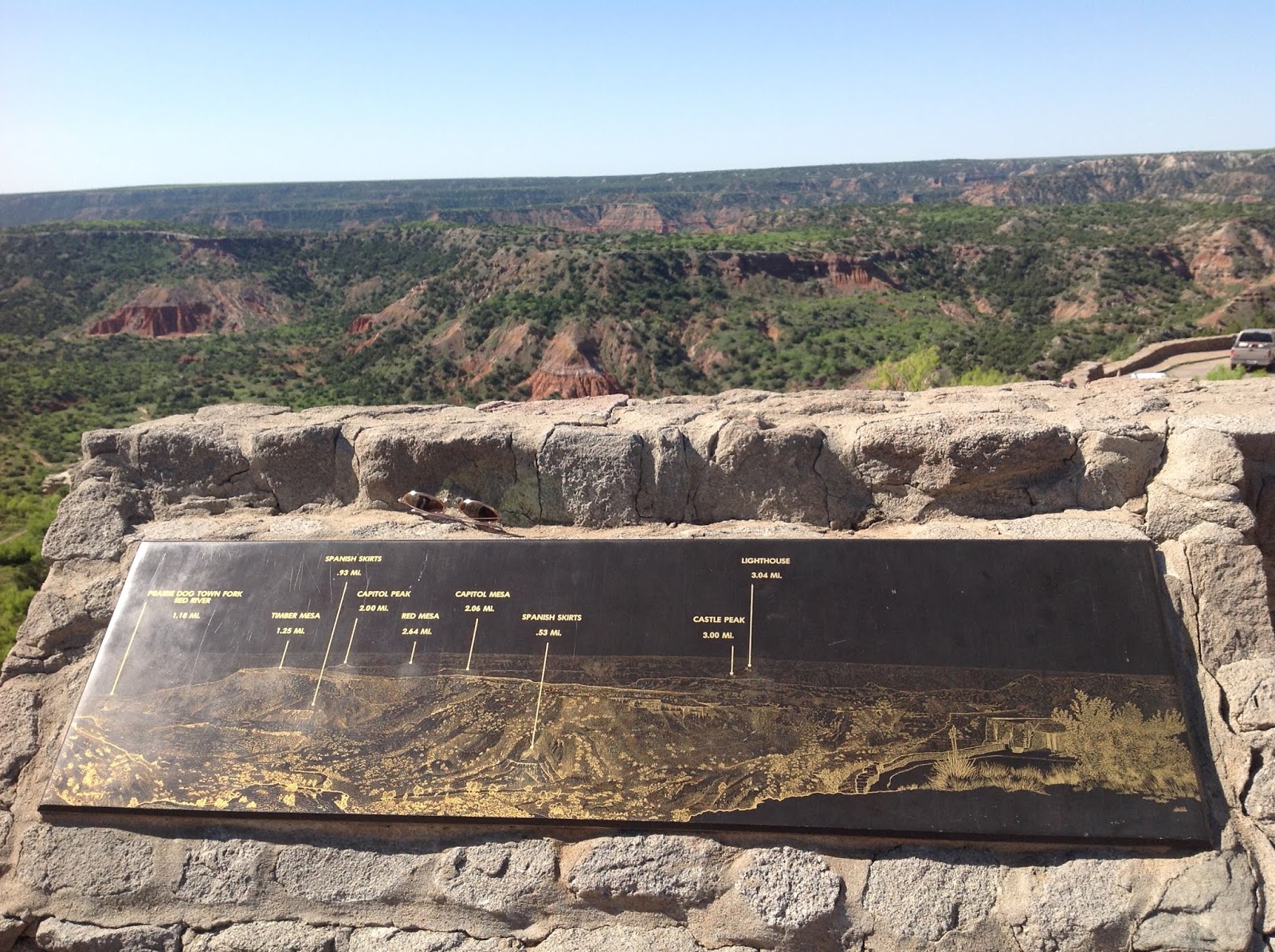 |
| A map of the prominent features at Palo Duro |
From there, we
ventured down the hill to the gift shop. Many more souvenirs were purchased. We
also spent some time learning more about the geologic and human history of the
canyon.
 |
| Savannah, mesmerized by the geology of Palo Duro |
 |
| Found some meteorology in the gift shop! |
We descended the
curvy road into the canyon admiring the strata along the way. We parked next to
the start of the Sunflower Trail, a moderately challenging 1.2 mile path along
the base of the canyon. We saw plenty of interesting sedimentary rocks, plants
(including cacti), several 5th graders (on a field trip) and even a black widow spider. Despite the general greenery
of the canyon, the stream flowing along the trail was about halfway up its
banks.
We were treated to
several lovely views of the canyon.
 |
| Palo Duro Panorama. Much greener than normal. Photo: Hunter Reeves |
 |
| At the bottom of the canyon, looking up |
 |
| Looks like the Old West. Photo: Maddie Bernabei |
After completing the walk, it was time to return to town for lunch. Some of us dined at Fat Boys BBQ and, let me tell you, it was a fine meal. Some of the best brisket I have ever had.
The afternoon’s
agenda included a tour of the Panhandle Plains Historical Museum. It is located
on the campus of West Texas A and M. It is one of the finest museums I have
ever had the pleasure of touring. If there is anything you wish to know about
the Panhandle region, you can learn it here. Exhibits included video
recreations of a bison hunt (not one piece of the bison went to waste after it
was downed), a scaled-down version of a frontier town, information about Route
66, and some older model cars which traveled along it.
 |
| Water extraction. Windmills are versatile |
 |
| Native Americans processing a fresh kill.. |
 |
| Classroom of the 1880's. The tools may change but the concept stays the same. |
 |
| This was adjacent to the schoolhouse. Just sayin'. |
There were some
displays devoted to the geology and paleontology of the area. For example, did
you know that a mountain range once ran across the Texas Panhandle and into
Arkansas? Over time, it was buried by runoff from the then much taller Rocky
Mountains. The Amarillo mountains, as they were called, are buried several
miles beneath the surface and are a source for much of the petroleum products
extracted from the area.
 |
| Diagram of the Amarillo mountains. They outcrop in Oklahoma. |
Exhausted from the
dizzying array of history we had just witnessed, we returned to the hotel. In
order to remind ourselves that the weather would change, and quite likely for
the worse, Greg and I had a briefing in my hotel room to discuss the severe
weather outlook for Friday. It had the potential to be a significant day if
the capping inversion would break. A capping inversion is a layer of warm air
aloft which prevents surface air from forming into thunderstorms
Hungry from the days’
events, it was time for dinner at the Big Texan Steakhouse in Amarillo. Its
chief claim to fame is the “free” 72oz steak. If you can consume a 4.5 lb
sirloin steak, salad, baked potato, roll, and glass of sweet tea in one hour,
your meal is free!
 |
| An institution and a mandatory stop in Amarillo |
I have been to the
Texan many times and have yet to see anyone successfully complete the
challenge. It is daunting, especially when you see the actual meal on display
in the lobby. I have never thought of trying it considering that I am always
there when I am chasing. The thought of carrying that much beef with me while
trying to track storms makes my insides hurt.
None of our students were
in the mood for that much free steak, though. They did try some of the smaller steaks for
sale and agreed that they were quite good.
 |
| Yes, it tastes as good as it looks |
The night wrapped up
with a visit to the gift shop and general enjoyment of the restaurant. Besides
the food, the Big Texan is a really cool and fun place to hang out. I recommend that you stop in if you ever find yourself in Amarillo.
 |
| The big stage at The Big Texan. Photo: Greg Nordstrom |
Day 6 - More Canyon (is not a bad thing...) - May 15, 2019
As with any job, you are given days off.
Storm chasing is not unlike a job as you have to work hard to forecast the
threat and then chase after it. Even with the lack of storms, we had been
pretty active with exploration and long drives. So, with that in mind, and
still no storms in the forecast, we elected to take the day off.
We had lunch at Braum’s and went back to
the hotel. Braum’s is a combination burger joint and grocery store. They are
well known across the southern Plains for their delicious ice cream. Fun fact:
they only allow franchises within 300 miles of their dairy farm in Tuttle, OK.
We returned to the
hotel and assigned the students the task of developing a forecast and potential
chase target for Friday. It was an opportunity for them to put their knowledge to the test. Then, Mr. Nordstrom and I retreated to a nearby movie
theater to watch “Avengers: Endgame”. A fine film and well worth the three
hours we invested.
Then it was time for the students to
present their cases. They were divided into two groups. Both chose targets in the proximity of a dry line bulge. A dry line is a boundary which
separates dry air from moist air. It is a frequent generator of thunderstorms
in western portions of Texas and Oklahoma during April and May. A dry line
bulge is an area where part of the dry line has moved ahead of the rest; it is
known for generating rotating thunderstorms due to changes in wind direction
along it.
Both presentations were well done. We
closed out the night with dinner and plans for more tourism the next day.
Day 7 - Volcanoes and Dilemmas - May 16, 2019
Thursday dawned and
it was time to (reluctantly) bid farewell to Canyon. At least for today; there
was a chance we would be back on Friday (or even the following Monday)
depending on where the storms formed. But for today we were headed back to New
Mexico to check out the Capulin (Cah-poo-leen) volcano.
 |
| Capulin |
Capulin, which means
“choke cherry” in Spanish, is part of a field of dormant volcanoes in the far NE
corner of the state. As we drove, we saw a few of the other volcanoes. They
stood in stark contrast to the otherwise flat land. In all my travels across
the heart of the country, I had yet to visit Capulin. Seeing all those other
cinder cones had me pretty excited.
We stopped at the
visitors center to pay the entry fee. Then it was up a narrow, winding road to
the edge of the caldera. We were nearly 9000 feet above sea-level when we
arrived at the top. I could definitely feel the reduced oxygen content.
The views of the
volcano and the surrounding flat plains were amazing. It made me wonder
what it would be like to observe storms from there. Honestly, probably not the
best idea because of lightning. We were at a high enough elevation to see the
snow-covered slopes of Taos, NM in the distance.
 |
| Real and spectacular |
 |
| View from Capulin. Photo: Hunter Reeves |
 |
| In the Capulin caldera |
 |
| Fortunately, the plumbing was stopped up while we were there. |
There were two trails
you could walk while at the top. One went around the rim of the caldera while
another went down into the caldera itself. I guess I was the only one who did
not complete the caldera trail; it was quite steep and I tired quickly after a
short ascent. I returned to the parking lot and walked down into the caldera.
It was a fascinating experience despite the physical toll.
Take the Capulin tour with Shaley Dawson:
Take the Capulin tour with Shaley Dawson:
Our adventure
complete, we headed for Dumas, TX to spend the night. Dumas was a location
which offered many possibilities. It was ideally located for any storms that
developed in the Panhandle region. And if for some reason that possibility
evaporated, we could still get up early the next morning and make our way
either north (Nebraska) or further south (Ft. Stockton).
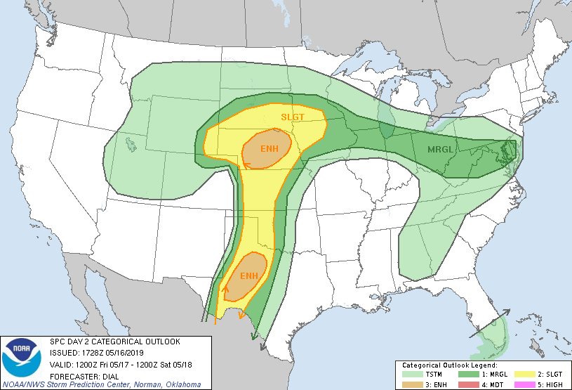 |
| Outlook for Friday. Decisions, decisions |
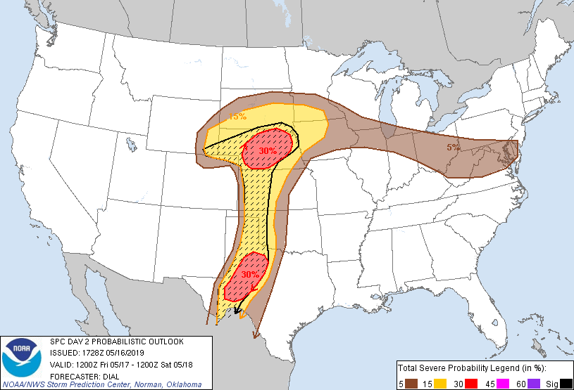 |
| Probabilities of severe weather. The black hatching indicates the probability of significant severe weather (Hail > 2", EF2+ tornadoes, a/or Wind gusts of 65+ kts) |
After dinner, Greg
and I met to discuss look over the data and discuss the possibilities. It was
clear to us that we had three possible options:
1) Get up and go
north to the Nebraska Panhandle, where the capping inversion would weaken and
tornadic storms would develop.
2) Get up and head
south towards Ft. Stockton where the atmospheric dynamics weren’t quite as
impressive, but there was a lot of instability.
3) Wait in the
Panhandle. There would be plenty of wind shear and instability, enough to rival or surpass the other two, but a strong cap would be in place most of the day. The key would be the dry line and any uplift it could provide.
Of the three, option one had the least
risk. We felt strongly that there would be tornadoes in Nebraska. But that
would take us out of position for chasing on Saturday. We thought there was a
decent risk for storms in eastern Texas in the late afternoon on Saturday. Chasing in Nebraska would leave us out of range for Saturday.
The same could be said for option two (Ft.
Stockton). Tornadoes might be a little less likely there because of the weaker
dynamics. But the weather models were showing only a storm or two developing; less competition meant easier access to a greater amount of instability. But,
again, chasing there would put us out of position for Saturday.
Option three was the riskiest as there
was no guarantee that the cap would break. It was entirely possible that we
could sit there all day with nothing to show for it. But, if it did we would
have three more shots at chasing, including Monday which was shaping up to be a
full-fledged tornado outbreak.
Rather than make the call ourselves, we
contacted the students and asked for their input. After presenting all of the choices, they elected to stay in the
Panhandle in order to maximize our chasing opportunities. With that decided, we all
went to bed to see what Friday would bring.
Day 8 - Our Patience Pays Off - May 17, 2019
With the die cast for
Dumas, there wasn’t much to do other than wait. Wait to see if the capping
inversion could be overcome and supercells could develop.
The morning soundings
did not paint a pretty picture for convection. From Midland, TX to Dodge City, KS, significant caps were in place, with lots of convective inhibition (atmospheric
energy devoted to suppressing convection) above the surface.


Even North Platte, NE, which was in a highly favorable area for convection, had a lot of CINH. But
storms were still likely there because the upper level flow and a warm front to
help break the cap.
We set up shop in the
dining area of the hotel in Dumas. Their hospitality was greatly appreciated.
We spent the afternoon closely monitoring surface data (for evidence of the dry
line bulge) and visible satellite imagery (for areas of cloud development). As
we waited, storms developed in both of the other target areas.
This is where chasing
gets tough. You spend most of your time waiting for things to develop. Someone
described it as driving thousands of miles and spending hours upon hours for 30
minutes of action. Further complicating things were the reports and imagery of tornadoes coming from Nebraska. But,
we stuck to our guns and stayed right where we were.
 |
| The waiting is the hardest part |
The capping inversion
held strong for most of the afternoon. Cumulus clouds would develop but could
not grow very tall. The group was growing uneasy and increasingly frustrated. Near
Childress, TX one of the most pronounced
dry line bulges I have ever seen (40 degree difference over a 30 mile distance,
with strong southeasterly winds ahead of it) developed. Despite this, no storms
fired in that area.
Finally, some cumulus
clouds managed to develop in the vertical off to our north around 5:30. With
the cap squashing everything else we had little choice but to go after it. Our
initial destination was Perrtyon, TX.
Along the way we
encountered the dry line. It was obvious, even without instrumentation. Behind
it, there was hardly any dust or pollen in the air. Visibility was high. As we
approached the boundary, you could see the haze and dust. It was most
definitely a dry heat behind the boundary and a sauna ahead.
 |
| Green line is the dry line (radar is picking up dust and bugs). Returns west of Beaver became a tornadic storm. Returns near Cimarron, Montezuma, and Spearville are windmills. |
Clouds struggled to
maintain their depth in the capping inversion, but eventually one of them broke
through and exploded into the vertical. With the wind shear present the storm
rapidly transitioned to a rotating supercell.
We intercepted it west of Forgan, OK and watched a wall cloud develop at the base. A wall cloud is the precursor to funnels and tornadoes. It indicates that the circulation within the supercell is extending towards the ground.
 |
| Explosive development |
We intercepted it west of Forgan, OK and watched a wall cloud develop at the base. A wall cloud is the precursor to funnels and tornadoes. It indicates that the circulation within the supercell is extending towards the ground.
 |
| The Wall Cloud |
Within minutes, the
wall cloud was rotating and a funnel cloud appeared. The storm was moving away
from us to the north. We pursued it towards the Kansas border, watching as the
funnel made its steady descent towards the ground. The contrast of the funnel
with the background of the storm was fantastic. The condensation taking place
within the funnel appeared white.
Finally, the funnel
reached the ground. We had a tornado.
 |
| The Tornado |
 |
| Savannah and friend (Photo; Savannah Tennyson) |
While watching the
tornado, we saw several pieces of severe-sized hail on the ground.
 |
| Oh, Hail. The alternating clear and cloudy portions indicate different types of growth within the storm. Quarter-size means it's severe. |
We watched the
tornado grow in size as it moved to the north. It was in an ideal location;
there were no cities and almost nothing in terms of houses and farms in the
area. The storm was carrying the storm away from us and we could go no further
on the road we had taken. So we had to backtrack to highway 23 so that we could
move north and reacquire the storm.
We reacquired the
storm near Meade, KS where it produced another tornado. We watched that tornado
disperse as it continued to move north.
 |
| Second Tornado. Photo: Greg Nordstrom |
We continued through
Fowler. Near Minneola, a tornado formed again. This time, it had a highly
curved structure.
 |
| Third Tornado. Winds near the surface cause the circulation to bend. Photo: Greg Nordstrom |
The sun was setting
and visibility declined. But the tornado was still there and growing in size.
We followed it for as long as possible before it became too dark to see. By
that time we were 20 miles from Dodge City. Since it had been better than 8
hours since we ate, the group was quite hungry. We rolled into IHOP and put
away quite a few eggs.
In the meantime, the
chasing situation for Saturday had become much more favorable for us. A piece
of upper-level energy was forecast to move across western Oklahoma late in the
day. It might not spawn tornadic supercells, but it would produce storms. Plus,
it was much closer than SE Texas.
After dinner, we made
the trek to Woodward, OK. We got suites at the Holiday Inn Express and slept in preparation for the next day.
Besides the tornadoes
and incredible structure, this chase was particularly satisfying. As a group,
we stuck to our forecast target and did not deviate even though the SPC did not paint a very favorable picture.. Further, no one was injured or killed as a result of the storm which
formed.
The NWS in Dodge City later rated the tornadoes as an EF3 and 2 EF2's
The NWS in Dodge City later rated the tornadoes as an EF3 and 2 EF2's
 |
| All three targets verified |
Subscribe to:
Comments (Atom)
-
After the effort we expended the previous two days, we took this day to gather ourselves and prepare for the marathon that Monday was settin...
-
We left the friendly confines of Yukon under a High risk. This category is reserved only for days with the highest potential for large, lo...
-
 With the die cast for Dumas, there wasn’t much to do other than wait. Wait to see if the capping inversion could be overcome and supercells ...

